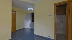
Sold
Hoi Tak Gardens Block 1FLOOR 3FLAT H
Registration Number:18062903020792
|Transaction Date:04/06/2018
PRN:B4680471
Land Registry
PRIVATE RESIDENTIAL

MariaChan陳少瓊
SENIOR ACCOUNT MANAGER(E-337914)
Sold


1/2
keyboard_arrow_left


keyboard_arrow_right
PRICE
$4.4 M
Saleable Area
312sq.ft.
Buy $14,096 /sq.ft.
Gross Area
450sq.ft.
Buy $9,778 /sq.ft.
Room(rm)
-
Efficiency Ratio
-
Direction
-
Building Age
38 Years
Transaction Date: 04/06/2018
Estate Overview
Date of Occupation Permit
1986-11
No. of Phases
-
No. of Blocks
3 Block(s)
Total Units
348
Walking To MTR Station
-
Address/ Area
13-17 Wing Fat Lane
School Net
Property Management Company
富城物業管理有限公司
Category
-
Developer
TAI CHEUNG HOLDINGS
Other Facilities
Swimming Pool, Children Playground/Play Room, Terrence Garden
Estate Properties
District Properties
By School Net

HOI TAK GARDENS Block 32Rooms
Saleable
325sq.ft.
Gross
476sq.ft.
$
3.35 M

HOI TAK GARDENS Block 32Rooms
Saleable
325sq.ft.
Gross
476sq.ft.
$
3.35 M

HOI TAK GARDENS Block 32Rooms2Living Room(s)
Saleable
312sq.ft.
Gross
450sq.ft.
$
3.2 M

HOI TAK GARDENS Block 32Rooms2Living Room(s)
Saleable
312sq.ft.
Gross
450sq.ft.
$
3.2 M

HOI TAK GARDENS Block 22Rooms
Saleable
325sq.ft.
Gross
476sq.ft.
$
2.85 M

HOI TAK GARDENS Block 22Rooms
Saleable
325sq.ft.
Gross
476sq.ft.
$
2.85 M
Estate Properties
District Properties
By School Net

HOI TAK GARDENS Block 32Rooms
Saleable
325sq.ft.
Gross
476sq.ft.
$
3.35 M

HOI TAK GARDENS Block 32Rooms
Saleable
325sq.ft.
Gross
476sq.ft.
$
3.35 M

HOI TAK GARDENS Block 32Rooms2Living Room(s)
Saleable
312sq.ft.
Gross
450sq.ft.
$
3.2 M

HOI TAK GARDENS Block 32Rooms2Living Room(s)
Saleable
312sq.ft.
Gross
450sq.ft.
$
3.2 M

HOI TAK GARDENS Block 22Rooms
Saleable
325sq.ft.
Gross
476sq.ft.
$
2.85 M

HOI TAK GARDENS Block 22Rooms
Saleable
325sq.ft.
Gross
476sq.ft.
$
2.85 M
Unit Transaction(7)
Building Transaction
Estate Transaction
Region Transaction
$4.4 M
Land Registry
$2.1 M
Land Registry
$1.44 M
Land Registry
$650 K
Land Registry
$610 K
Land Registry
$1.05 M
Land Registry
$1.23 M
Land Registry
Map
Google Map
Map
Google Map
Map


